


As mentioned in my last post, after leaving Little Styx River camp we headed for Armidale to plan our trip to Pilliga Forest over a cup of coffee. We did drop into Wollomombi Falls on route. Wollomobi falls are quite impressive, from the very top to the very bottom the height is approx 220 metres although its biggest drop where the water “falls” is only 100 m.
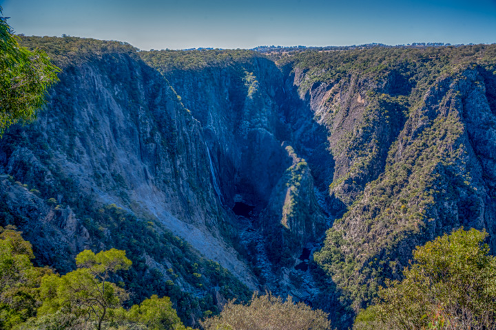
Wollomombi Falls
It was to be a reasonably long trip of about 450km but on back roads would make the trip at least 7 or 8 hours. As we know, good plans can go wrong and it seems that our maps were not up to date. Not that the roads did not exist, it was just that it appears that the authorities have prevented entry into state forest and/or nature reserves by back roads and in many cases have closed many of the roads in the forests to the public. We had Pilliga Nature Reserve fair and square in our sites as we had visited this area before and found the camping and bush very much to our liking and a great place to chill out for a couple of days. It really is a spot that unless you know of its existence you would not easily find. My brother and his wife put us on to it a couple of years back and it is a spot we were keen to revisit.
View Armidale to Pilliga Nature Reserve in a larger map
From Armidale we headed down the New England Highway and by the time we did the 65 Kms to Bendemeer we had just about had enough of B Doubles and 25 Foot caravans so we looked to take a short cut on back roads through to Manilla and then onto Boggabri situated on the Kamilaroi Highway. This drive was spectacular, winding its way through the ranges along the Halls Creek valley and then joining the Namoi River just before reaching Manilla. The scenery along some of these back roads is amazing and makes for a much more enjoyable journey than charging down the highway, even if it does take a lot longer. From Manilla we headed to Boggabri along the (you guessed it) Boggabri-Manilla Road where we filled up with diesel. From Boggabri, our maps indicated that there was a good chance we could enter the Pilliga Nature Reserve/Forest from the east, then cross the Newell Highway, (Pilliga Nature Reserve straddles the Newell Highway) and into the camping area.
Bugger! The red route on the map above is where we wanted to go but were stopped by “No Through Road Signs” whenever we got near to the Pilliga Reserve/Forest. Eventually we got back on a more substantial road and headed directly south to Mullaley on the Oxley Highway. By the time we reached Mullaley it was getting late in the day and had no chance of reaching our destination that night so opted for a camp spot behind the Pub. Good value, $15 per night with power. Not salubrious but adequate (just). We set up camp then headed for the bar for a drink and mix it with the locals. A very friendly lot of customers and with the obligatory young female European backpacker working behind the bar. On this occasion she was Irish and a delight. I think I have said it many times before, but if it were not for young female backpackers from Europe on working visas, it would be dammed hard to get a drink in a bar in the bush.
After a couple of sherbets we headed for the showers and then back to the bar for dinner having previously checked out the menu.
As is usual in bush pubs, you get a meal at a very reasonable price that you couldn’t jump over. I guess quantity has to make up for quality, but on this occasion the quality was not too bad. During dinner we were kept amused by a local truckie who had taken a shine to us and wanted to chat. Really nice bloke; as most people seem to be in the bush.
The next morning we headed West to just short of Coonabarabran then North along the Newell Highway for the Pilliga Nature Reserve and on the way we dropped into the Pilliga Pottery for a coffee and a look see. We have been to the pottery before and while the drive in is a fair distance (around 20k) it is well worth the effort. In fact it is astonishing to believe that such a large pottery can survive by just selling their wares to tourists who happen by. This is no little backyard artist who has a hobby that they have turned into an income. It employs quite a number of people; the output is huge and in great demand, despite the items being reasonably expensive. An absolute must see for anyone travelling in the area and is staffed by very friendly people happy to demonstrate techniques and show you around the extensive factory. They also have accommodation available in a wonderful bushland setting.


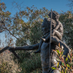
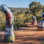
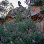
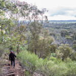
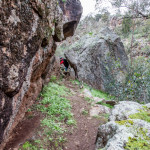
After our coffee and a look around we set off for the Pilliga Nature reserve arriving around lunch time or a little after and nothing had changed from our last visit. We once again had the place to ourselves. Even if there were others there it would not have mattered as the camp sites are large individual areas so that you have a great deal of separation and privacy from fellow campers. As is our normal practice we chose the site that was farthest away from the facilities and set up our camp. We had the place to ourselves and were looking forward to a 2 night stay. We decided that we would do the Sculpture and Gorge walk twice, once in the evening and again in the morning to catch the different light. It is not a long walk, only about 3 or 4 km, but it is a very pleasant walk.
-
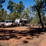
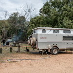
- Our Camp at Pilliga Nature Reserve
-
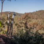
- Pilliga Sculpture Walk
-
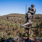
- Pilliga Sculpture Walk
-
- Pilliga Sculpture Walk
-
- Pilliga Sculpture Walk
-
- Pilliga Sculpture Walk
By the time we had returned from our afternoon walk there was another camper set up and on walking past their camp on the way to our own camp, Chris was approached by the woman enquiring “HOW DO WE GET OUT OF HERE”. I had taken a different route back to our camp and so was unaware of the situation until Chris returned to our camp to fetch our maps. On returning to their camp it became apparent that our maps were no better than theirs, with none of the roads/tracks into the reserve being shown. We had used our 4WD electronic Hema Navigator to navigate the area and so were not aware that the 2 atlases that we had with us did not have the detail that was required. So after grabbing the Hema Navigator we set them straight on how to exit the reserve and head out through the small town of Baradine.
Looking forward to a great day the following day we had a game of scrabble then retired early. During the night we were aware that there was some light rain. Bugger! To make it worse when we got up in the morning we could here the rumbling of an approaching thunder storm in the distance. Now this would not normally worry us, as on our normal treks we would simply batten down and wait for the weather to improve before heading off, but as we were on a reasonably tight schedule we decided that discretion should take priority and so quickly had breakfast and broke camp. We were on the road by 7:30, somewhat of a record for us with our normal set off time of about 9:30 am. The thunder storm was on us as we left our camp. It would have been useless hanging around for the day and we might as well be travelling in the rain rather than being cooped up in our camper itching to get out for a walk.
View Pilliga To Temora in a larger map
After Baradine we headed for Coonabarabran, then Mendooran via a secondary road and then on to Dubbo. Mendooran was a good find for future reference with fabulous free camping on the river and a fine local Pub.
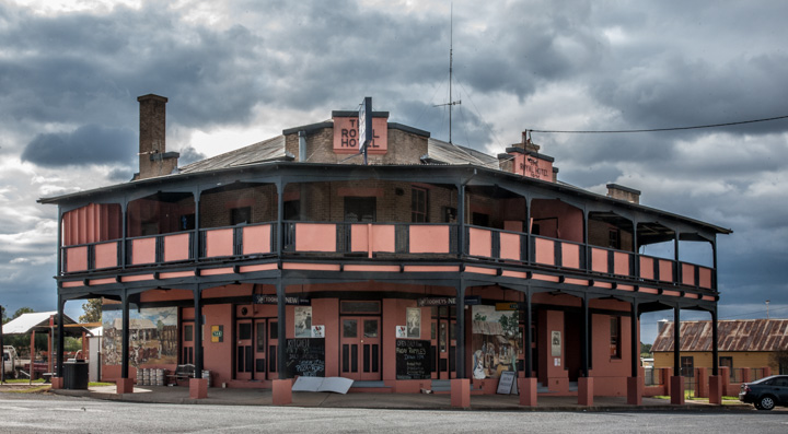
Royal Hotel Mendooran
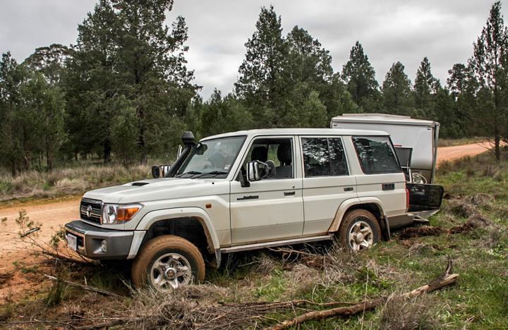
Quickly Passing through Dubbo we targetted lunch at Goobang National Park, in particular the northern campground (Wanda Wandong campground). After lunch we decided to check out the campground further south(Greenbah campground). While Wanda Wandong campground was OK we thought that perhaps the Greenbah campground, being in the centre of the park, may be a little more to our liking. So we set off, unaware that the track was not simply just another run of the mill dirt road. Well the the track was OK, but we were coming upon some very steep gradients and sharp creek crossings, but not a problem for the fabulous new 4WD wagon. At this stage we were still in 2WD and while negotiating a very steep section of the road and remember that we are towing a 2 tonne camper, a vehicle (4WD) coming from the opposite direction flagged us down. Their sole purpose was to enquire if we new what we were getting ourselves into with the camper/caravan attached and to warn us that it was 4WD only and not designed for Caravans/Campers.
We said “no worries we will be OK”. Now why you would get someone to stop while negotiating the steepest hill (and loose gravel to boot) in the park is beyond me but I guess they just thought that they were doing the right thing by us. Once they had given us the dire warning of things to come, off they went down the hill leaving us to start up the incline again on a very loose surface. We engage our free wheeling hubs, selected low range 4WD and set off, not without some worrying wheel spin and loss of grip. Had we not been stopped and kept some inertia we would have got to the top of the hill in 2WD. Anyway, that hill out of the way it became apparent that when we had met with the people who flagged us down we had already negotiated the worst part of the track and the rest was a picnic. In fact the whole track could have been negotiable by a normal 2WD sedan if not towing anything.
We set up camp at the Greenbah campground which only has 6 camp sites nicely separated from one another, and it was much more picturesque than the northern campground and with only 1 other camper on our arrival.
-
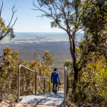
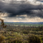
- Looking West across the western plains
-
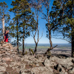
- Trig Point – Goobang National Park looking west
-
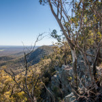
- Western Ridge – Goobang National Park
-
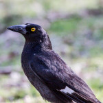
- Currawong – Goobang National Park
-
- Goobang National Park Fauna
-
- Greenbah Campground – Goobang National Park
Goobang National Park is the western most extremity of the Great Dividing Range. The ridge on the western side of the park gives you a most magnificent panorama of the western fertile plains before the drier country further to the west. (Zoom in on the map above or click the link to the larger map). While it is great to see, photos are a total waste of time as is the case with a lot of the Australian landscape. It is so vast that it is impossible to photograph well.
During the afternoon of our second day at Greenbah Camp we were literally invaded by a group of about 40 campers. This in a campground of 6 camp sites. We came to the conclusion that they must have been a Church group from one of the more way out “sect” type churches, as to engage in conversation was almost impossible. They had absolutely no time for us heathens. However they were very quiet and their kids were well behaved but thankfully the next morning we were headed off in any case. The weather was still terrible with some drizzle around.
It was now the 19th of August, so had plenty of time up our sleeves to get home by the 26th. We headed South down the eastern sided of the ranges and then joined the main road at Parkes, then on to Forbes and then back onto a minor road to Grenfell. We were headed for the Weddin Mountains National Park, yet another section of the Western most Ranges of The Great Divide. The first spot we checked out was a camp ground (Holy Camp) close to the town of Grenfell on the eastern side of the range but not in the least an inviting place to camp. We were probably influenced by the light rain that continued relentlessly. So we headed for the Ben Hall Campground on the Western side of the range in the hope that it was more to our liking. The Ben Hall Campground is excellent so we set up camp, gathered some wood for a fire and settled in. There were a few great walks, not of any great distance but we had to fit the walks in between rain showers so being short helped keep us dry.
Weddin Mountains turned out to be a very pleasant spot with the hi-light being Seaton’s Farm.
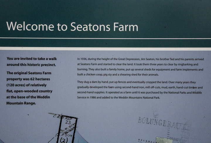
Seaton Farm History in brief.
This historic site was truly amazing and tells the story of some very ingenious battlers during the great depression. This farm was completely built from materials that were readily available, whether it be from the bush or cast off’s from others. Nothing was purchased new. But by all reports they were very happy despite the poor quality of the country and the difficulties of living from day to day. As an example Jim Seaton hand made 3 km of kangaroo proof fence by hand, with posts of local saplings (Cyprus Pine), which are rot and vermin proof.
-
- Ben Hall Campground – Weddin Mountains
-
- Cosy Fire – Plenty of firewood available – Ben Hall Campground
-
- Rain Squalls approaching Weddin Mountains
-
- Ben Hall’s cave walking track
-
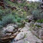
- Bertha’s Gorge
-
- Bertha’s Gorge Walk
-
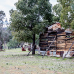
- Seaton’s Farm
-
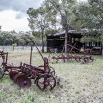
- Seaton’s Farm
-
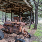
- Seaton’s Farm
Ben Hall (the bush ranger) was believed to have hidden out in one of the caves close to Seaton’s farm that you can access by walking track.
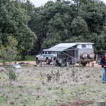
After 2 nights at Weddin mountains we set off for the Murrumbidgee to find a good camp spot. I decided that as we would probable be spending some time in larger towns I should put on some better clobber than I had been wearing. Yeah Great!
We turned right exiting the entrance to the park and 100 metres down the road we decided we were headed the wrong way, so I decided that we should do a “U” turn. Engaged 4WD “just in case”, off the road to the left, turn back onto the road and into the rough on the opposite side of the road to complete the turn. And there we stopped, front right wheel eighteen inches from solid ground. No problems; “just engage the front and rear diff locks” says me, and we will be out of here. Not on your life, there we stayed.
The worrying thing was that for the 2 days we were at Weddin mountains we had only briefly seen a day visitor on the first day; not a sole since.
So out with the shovel and the axe. Really frustrating as this was to be a non adventurous trip, so no recovery gear and no winch installed on the new car as yet. And no UHF radio. We cut down a good number of Cyprus Pine saplings and cleared the mud from the wheels and we were able to progress another 6 inches but that was it. Frustratingly close to the solid road. Under the seemingly firm surface it was bottomless slush. We simply went in deeper.
Back at the entrance to the park we saw a 4WD enter, but waving had no effect. Oh well, he will come out soon and hopefully we can get out of here. When the guy eventually appeared from the park he stopped to lend a hand. However he had no recovery gear either. So, leaving Chris at the roadside with our car, John (our rescuer) and I set off to fetch help. We headed towards Bimbi checking in at farms on the way. While we found cars that were still warm from running with keys in the ignition, washing on the line, dogs in utes, open back doors, music playing, we could not find a single human after visiting 3 farms. So eventually arriving in Bimbi, 18 kilometres from where we were bogged we found a good Samaritan to come and help us. So after about 4 hours we were eventually on the road again. Offered John some money for fuel, but he would not have a bar of it. “I might need rescuing myself one day”. The bloke who towed us out however was pleased with the thought of my donation to his beer budget. He had his wife with him and very typical of bush people ready to give a hand to anyone in strife.
Bogged at Weddin Mountains 5 minutes after leaving camp.
So much for my clean clobber that was now covered in mud from head to foot. We headed for Temora, looking for a caravan park with laundry for obvious reasons.
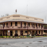
The weather was still bitterly cold and wet. So we were not happy campers, hoping that the weather would improve as we got closer to the Murrumbidgee, we set off the next morning for Narrandera passing through Coolamon, where I took a photo of the Coolamon Pub. I have a bit of a thing about country pubs and like to photograph them.
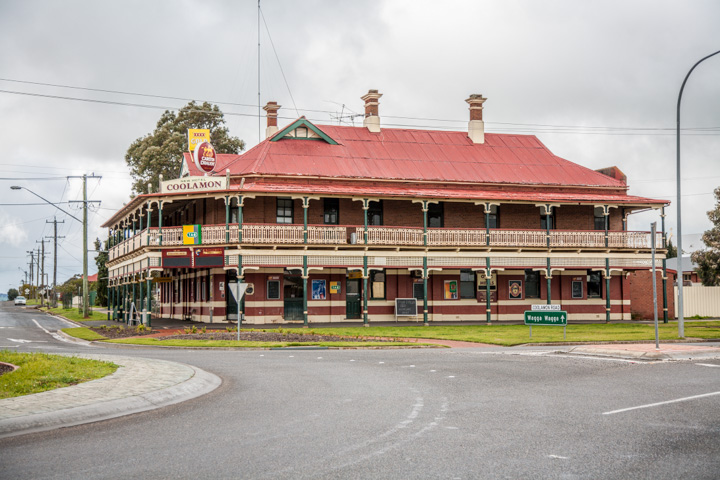
New Coolamon Hotel
Arriving in Narrandera late morning we checked out the Talbot Lake caravan park as a back up then headed down the Murrumbidgee in search of a camp spot. This was to no avail and the weather continued to be discouraging so we headed back to the caravan park and checked in.
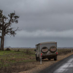
Setting off the next morning heading in the general direction of Corowa and maybe some camping along the Murray river, having given up in the Murrumbidgee for this trip, we continued to drive through rain.
At Morundah on the Newell Hwy we turned off and headed on a back road to Urana (where I obviously took a picture of another pub).
-
- Hotel Urana
-
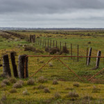
- The country side is appreciating the rain
-
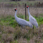
- Brolgas on the Morundah – Urana road.
-
- Travelling the Morundah, Urana road.
Not far down this road, with rain continuing to fall we decided that on such a short trip it was not really worth putting up with bad weather for the limited time on the road. When we are out and about for months at a time, we would simply batten down and wait for the weather to clear, but with setting up for one night stops it really is not worth it, so we came to the decision to head straight for home that day arriving mid afternoon on the Friday, 2 days before we had originally planned. The only exciting thing that day was chasing some Brolgas across a wet paddock without really getting a good shot.
View Temora to Home in a larger map
This trip more than ever made the investment in the Diesel Space heater in our camper a great investment. Balmy 22 degrees in the camper while bitterly cold outside.
End of Trip!!
Time you bought some Maxtracs Graham – they would have got you out……
Checked them out
Yep your right. – they look like the goods
Cheers
Graham
nice trip graham; sue and i have done some of the areas when we traveled to byron bay. like your new fleet. we have just arrived back from italy and spain and are looking at some bush travel next year. cheers to chris.
regards, mick and sue.